Tropic of Capricorn Part 2
To imagine that Tonga is actually an independent nation by its own right is nearly unbelievable since it is so tiny and is actually a collection of miniscule islands, with Tongatapu Group, of which Eua is the southernmost, being the largest of all. I wonder why it isn’t under any other countries occupation or sovereignty! Landfall means the first sighting of land and as the lookout with a telescope stuck to your eyes, you are supposed to scream from the crow’s nest at the top of your voice ‘Land ahoy!’ and then the all-knowing captain would come down, snatch the telescope from the novice’s hand and shrug, ‘Hmmm, you just got lucky, I would have seen it if I wasn’t drowning in wine.’ So we make ground in the bay of Tufurai. This postage stamp sized island measures only around 12 miles at its longest and 4 miles at its widest. Despite that it remains one of the least explored islands of Polynesia. Almost all of it falls under the national park and is hilly and covered with volcano ash, though there are no volcanoes on the island.
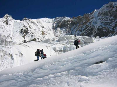
Now an interesting fact, Eua is the only island in the kingdom of Tonga that has a river running through and the only bridge in Tonga is here that helps us go across to the capital of Ohonua. Now we must hurry up and climb the hills and to the highest summit of Te’emoa (chicken shit) that at 382 meters has the solitary grave of a soldier right at the top. The island is lush green and the view from the top is jaw-dropping. We would rest a while here and then go to explore many of the caves and potholes in the island. For exploring the island we can go by foot, bicycle or on horse – so take your pick. And to make me entirely happy this island also has hilly trekking trails. To the north we would walk up to the coastal cliffs that fall off straight into the sea nearly 120 meters down and is a good lookout for whale watching since the water is so deep right next to the land that the whales come very close. Due to the cliffs all around this island has only bathing-worthy beach close to the villages so let’s do more caving, should we! The rainforest in the park will show us many exotic birds including lorikeets, musk parrots, pacific pigeons, kingfishers and tropic sea birds.
Soon after setting sail from Eua, a funny thing happens – we cross the International Date Line.
Essentially IDL is an imaginary line (don’t we have so many of these!) through the Pacific Ocean nearly corresponding and running along the 180 deg longitude. It basically divides our Earth in two halves of east and west. By international agreement the date on the east side of the line is a day earlier than to the west. You could physically be in the past and the future simultaneously if you straddle IDL. Umberto Eco dealt with it beautifully in his highly entertaining book, ‘Island of day before’. That tells the tale of a ship-wrecked sailor stuck on an island right on the IDL. The IDL like any other meridian connects the two geographic poles. This line deviates only at few places from a straight line, one being in the Bering Strait (I have sailed here) to avoid dividing Siberia into two different days and then deviates west to include the Aleutian Islands of Alaska in the same side. Into the Polynesian Islands it again deviates quite far to the east so as to include all the islands into the same time zone as of New Zealand. A reason could be Captain Cook who had single-handedly discovered majority of these islands prior to discovering New Zealand.
Now after sailing for nearly 1600 miles (which will take us around 12 days) we enter the Austral Islands and reach the Island of Tubuai that sits almost plumb on TOCAP. This too is a French Polynesian territory and belongs to France. I have no idea how they exercise any kind of control or governance in this island. This is one of the islands discovered by Captain James Cook in 1777. Like all French Polynesian Islands, Tubuai too is of volcanic origin and the ocean can reclaim it any time. Tubuai resembles the shape of a thumb print and is a laughable 5 miles by 3 miles in area. We should be able to walk all around its coast in few hours. But we must stay put in such places like Mataura, Tamatoa, Huahine and Mahu just for the names if for nothing else as we would be able to say forever that the evening in Huahine can outshine all other. Interestingly, Tubuai is one of the islands featured in the movie Mutiny on the Bounty. Well we are here to have fun, so let’s climb the twin volcano peaks and to the highest summit at around 420 meters. From the top when you look out into the emerald sea you will understand why despite its remoteness few people do still come here. The beaches are typically white and made of the finest sand and the water changes color from white at the beach to sheer shades of turquoise. And then time once more for us to depart.
From Tubuai we travel for nearly 920 miles and finally sight the Gambier’s Islands and we enter the Tuamotu Archipelago. Now let’s take a deep breath for we are about to enter the remotest island group in the entire French Polynesia and a place which is known to very few. I along with my shipmates must be the only Indians to have ever touched Gambier’s Islands. It is literally far from everywhere. An entire book can be filled up with the exotic and rare beauty of Gambier’s but here’s a very briefest of brief gist.
The main islands of this group are Mangareva, Akamaru, Aukena and Taravai. This exotic island group has a sad history of severe deforestation, nuclear tests by French military and housing thousands where naturally only few hundred can survive. Presently it is only a tourist hub and sporadic logging at places. The highest summit of Mt Duff in Mangareva at 440 meters is a must climb for us. Though spread across four major islands the area does not exceed 34 sq km. After Mangareva we must stay in Akamaroo too, which in my opinion is the prettiest of all the islands in this group. Now among all other offerings what’s great out here are the fruits on offer and it has the most succulent mangoes you will ever find anywhere. As far as I can remember the fruits we would get are mangoes, grapefruit, papaya, mandarins, guavas, lemons, breadfruit, pastiches, coconut, little red tomatoes and oranges. Most of the tourists we would see here are private yacht owners and families sailing from New Zealand. Drinkable water is scarce and we will have to use rain catching devises to stock up on water since after this we have a long haul across the vast expanse of the Pacific. We could stay in Rikitea for a while and walk around the island at leisure. The endless bays full of lapping waters would of course keep us busy with snorkeling and swimming. French wine is freely available and we must stock up on wine as well.
After this comes the second longest stretch of our trip, from here we would now only set foot on land when we reach the Chilean outpost of the famous Easter Islands after nearly 1750 nautical miles. Though the Easter Isles are more than 250 miles south of TOCAP and do not technically fall on our route, there’s no way we can avoid it, since Easter Island is the home of the famous and most mysterious stone statues in the world. There’s much to say about the Easter Islands since I have been here before. While en route let’s all get down to deck scrubbing, painting, cleaning etc and oiling the cleats and ball bearings and bottle-screws, clean the sails and polish the masts. Our boat must outshine all the others in the Pacific.
Continued….

Comments
Post a Comment