Toral Trauma – crossing Toral Pass (Jot) 4350m from Kangra to Chamba

Add caption
As October was coming to its conclusion, I decided to do one more Dhauladhar Pass before the festive month of November set in. This time we opted for Toral Pass, as my friend Ravinder had requested. This pass had been crossed by his shepherd forefathers and he had never been there so he wanted to visit the footsteps of his ancestors. Nearly 10 years back I had gone to Toral Pass from Kangra side and had returned back to Kangra therefore I presumed that I at least knew the first half of our journey. Once again we decided to do this pass unguided, just the two of us. And this subsequently proved to be an immense tactical error much to our chagrin. Despite our combined experience of over 50 years, we got stuck at one place, totally lost, which I completely attribute to our own errors of judgment and perhaps a good amount of complacency on my part. I will elaborate upon this as a lesson learnt not only for myself (even after a climbing career spanning 45 years and pretty much the entire globe) but also as something for all you climbers and trekkers, in a separate post. In this post I will describe what we did and how we completed the journey.
The Plan: we estimated a journey of 3 nights and 4 days starting from Salig, Kangra side and reaching Kuwarsi at Chamba side. So we packed food for 5 days keeping a day extra.
Day 1: 25th October. A friend dropped Ravinder and I till the road ahead of Salig that goes till the power house. The hiking trail begins from around 1600m, nearly half a km before you reach the powerhouse. You would see a wide well marked trail to your left going up. We found a solitary shepherd too upon the trail and he became our temporary guide. He cautioned that most likely we wouldn’t find much water at this time of the year and perhaps no shepherd either. The trail goes first through a forest climbing to a ridge and then drops down to the other side till it crosses a stream and arrives at a flat pasture with several shepherd houses. Our shepherd parted company here. Now the two of us continued along the well marked trail. Shortly we came across another group of shelters. The trail continued gently along the stream. Then we crossed the stream underneath a really ramshackle bridge, which we dared not use. Another 20 min later we crossed the same stream again to its true right bank where a rickety bridge suspended listless. Here we saw the old powerhouse with electric wires. Ahead we had to take the trail splitting to the left and not the one going right towards the barrage.


The trail thereafter climbs steeply through tall vegetation keeping to the true right bank of the stream. Then we came to the vast grazing ground where we crossed the stream to its true left bank. After a while again crossed to its true right bank. We soon reached a junction where another stream, much smaller, from our right cascaded down and united with the one that had so far been our companion. I faintly recalled from my previous journey that we would come across a cave to our left and then climb steeply through the forests, keeping the main stream still to our right. We climbed through the forest till we reached another split in the trail and took the one descending to the right as the one to the left went up through tall grass and bushes. We got down to the stream and came stuck at a mini waterfall. We couldn’t see any trail further. We searched a bit but failed to find anything. Though my mind said there had to be a trail further up somewhere in the area but we couldn’t find any.

We found a dry nullah going up but decided not to go up. So we retraced our step back to the split and now took the left trail, which soon completely disappeared through very tall grass and bushes. We returned and decided to go down to the junction of the two streams and take the other one, going up on the other side of the stream. This was an alternate trail to Ghuntu Goth, which we hoped to reach by day end. Little did we know what we had in store! We went down and crossed the main stream and then the smaller stream coming from our right and then climbed up on to a flat meadow, now covered with dry brown grass. Here we found a big shepherd cave shelter. And a trail that again split into two, one heading left back towards the main stream that we had been following earlier and another to the right and up. Here we made our second mistake. We took the left trail. We followed the trail and it brought us back towards the stream that gurgled to our left, eventually going down to the water level. Far up pretty much aligned with the stream I could see the top of Ghuntu Goth and I presumed that we will find a place to cross the stream and a trail to go there. Once again I was proved wrong. We tried for over an hour to find a trail across the stream for going up, but to no avail. So we retraced our path and returned all the way to the shepherd’s cave. And took the other trail heading right and up. This one brought us to another flat ridge top from where we saw a couple of cave shelters to our right. It was quite late by now and we decided to camp for the night next to one of the caves, which had a small stream running nearby. The cave was unusually clean with dry grass upon the floor and a small fire platform. It was a typical grazing area with tons of goat-dropping all around. We decided to cook inside the cave. We were at around 2400m. We found a solitary shepherd camped with his flock roughly 300m above us, right beneath massive southwest face of Dhauladhar Matterhorn, who told us that we could continue next day from above our cave but we couldn’t camp at Ghuntu (the regular shepherd campground) as there wasn’t any water, so we got to camp next day well below where there was a trickle of stream. He couldn’t tell us though if there was adequate flat space for us to camp.


Summary – started hiking at 0730hrs from 1600m. Arrived cave camping at around 1500hrs at 2400m. Normally you should be able to cover this distance in about 4/5 hours. We took longer due to our abortive attempts at finding the correct trail.
Day 2: as we had a short day today, we started at around 0830hrs. We first went straight up to the top of the pasture above us and then descended on the other side, crossing a massive grazing ground with a water source near big cave shelters. In case you follow this trail then this would be a better place for Day 1 camping. From here we could clearly see Ghuntu Got and the trail ahead towards the pass. We were headed into the stream that we had followed yesterday to a blind end. Today we descended, losing nearly 200m, into the stream, which we had tried to climb up through the previous day. We realized that with an hour or so of bushwhacking we could have reached this point yesterday itself. There were few flat grounds right beside to stream to camp and it had some amount of running water. We crossed the stream at a place and climbed up further and once again switching to the other side near a massive boulder. From here the trail climbs through grazing pastures, with the stream to our left and a sizeable hanging ice block far ahead up the stream. The trail brought us right beneath the ice block, where once again we crossed the stream to its true right bank and followed the trail that climbed very steeply through bushes and over big boulders. Another hour of boulder hopping diagonally upwards and to the right, brought us at level with the ice block, where we hoped to find a place for our tent, which we didn’t. So we climbed down till around 2800m where a tiny inclined patch offered us tent space and a boulder cover as our kitchen.


 |
| Descending into the nala on Day 2 |
We gratefully pitched our tent and Ravinder fetched water from a running stream around 100m away, the path to which lay through landslide scree. It’s only his Gaddi genes that made him cross this path to the stream several times barefoot wearing only rubber flip flops, quite out of question for me, as I observed ruefully. As it was barely noon, we went up further to Ghuntu Got for route finding. Which lay at around 3100m. We went up empty handed through the dusty steep slippery trail. Ghuntu Got had only a solitary temple, some signs of shepherd presence and absolutely no water anywhere at all. From here it is impossible to miss the trail since there is only one, which winds for the next 200m like a snake right at the top of the ridge to our north. We went up and I started remembering some of the features from a decade back. We returned after two hours. We had dinner and a nice hot campfire. In anticipation of a big day tomorrow we retired early.

Summary: started at 0830hrs from 2400m and camped at 2800m, below Ghuntu Got at around 1200hrs. Thereafter did a route recce via Ghuntu up to an altitude of 3200m.
Day 3 : with first light at 0635hrs we started going up. At Ghuntu we offered prayers at the temple, and then continued on the ridge through the massive boulders, gaining ground gradually. After that we had to go down to a grassy patch for a bit and then came the slope that is described as peeth thorni (back breaking) by the shepherds. It goes straight up through a stream (now totally dry) for nearly 280 vertical meters. We decided to do it nonstop. Atop we paused to breathe and click few pictures. On the other side the trail goes down and traverses to the right before climbing up soon enough. From then on it was anybody’s guess where the trail went, since you must follow it through all its twists, turns, drops and cracks. At several places we scrambled over slab rocks, then at places simply finger holds, while the trail continued forever. Every time we rounded off a ridge or a spur hoping that it would be our last, yet another ridge-spur would loom ahead.
 |
| Nearly 300m straight up this gulley |


 |
| sheer drop to the right |
Eventually we came
to the famous pallu tappa (Pallu’s
path). This feature where shepherds have placed slab stones stacked loosely one
on top of another, rises around 70m into the sky through a dihedral. The slope
is at least 60 deg and but for these stones it would be impossible to surmount
this part of the trail without adequate rock climbing gear. Ravinder had learnt
from his 92 year old granny that his great grandfather and his brother (Bakshi
Ram and Banka Ram) were the original architect who built this so called
stairway to heaven (or hell if you may prefer) nearly a century before.
Subsequently his great grandmother had supplied money to other shepherds to
maintain the path. The name allegedly comes from a shepherd named Pallu who was
the first to survey this trail and had identified this particular dihedral as
the path upwards. Pallu’s vintage is unknown but I would place it sometime at
the beginning of the previous century. It only boggles my mind at the shepherd
architectural marvel. We zoomed through the slab stone steps and onwards.
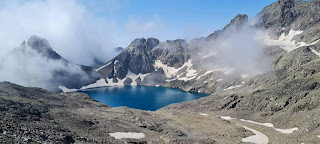
Several exposed rock traverses finally brought us to the top of the pass where
a big triangular shaped rock stands like a sentinel. It had taken us a little
over 6 hours to gain nearly 1600m. All through our climb we had been gazing at
the massive pyramid of Dhauladhar Matterhorn to our right and discussing how it
could be attempted. We scrambled down to the small rock assemblage with a red
flag that signified the temple. We did some puja and then continued further
down. At this time the descent was through huge boulder field, with hardly any
snow patches anywhere. Following the cairns that the shepherds had placed it
took us a further 90 min or so to reach Dali Kutla (3800m), a huge flat
pasture, the grazing rights to which belongs to Ravinder’s uncle at Lamu. If
there was water then this would be an amazing place to camp. We descended
further towards the trident temple that is the holiest shrine of Toral Swamy
(Lord Toral). Here Ravinder performed an elaborate ceremony since his granny
had specifically asked him to, offering a trident and copious amount of
incense. Thereafter we went down further to 3450m and camped near


Summary: started at around
0640hrs from 2800m, reached Toral pass top 4350m at 1245hrs.
Day 4: presuming that
today we would reach Kuwarsi Village in about 4 hrs, we struck off at around
0730hrs. There are multiple parallel trails here all on the true left bank of Churi
Nala, one must take the one that is nearest to the stream that way you avoid
many boulder fields and unnecessary ups and downs. On the other side of the nala
we could see the trail that goes directly down to Lamu. We had been cautioned
not to take that trail as it was too dangerous due to disuse. Little did we
know that our trail too would lead us to some serious problems soon. We
gradually descended to around 3000m where we came across the last of the
shepherd rock shelters. From here the trail climbs up, first through a series
of steeply inclined rock cliffs. Here is also a running stream, which we
realized later, was actually the last water point for the day. At that time we
didn’t realize this so Ravinder filled up his bottles and I kept mine empty. We
drank a bit too. The trail went up spiraling towards up and left, leaving the nala
far below. We crossed some wider pastures till we arrived at a sizeable grazing
ground, with six or seven shepherd shelters. The forest around the area was
totally burnt down. Here we got confused for another half an hour due to
multiple trails, till we found the one going towards our right across and
around a ridge. We kept following this roundabout trail as it led us from one
ridge spur to another, seemingly without any end. At one place we had to climb
through a very steep narrow gully, followed by several highly exposed traverses
amidst trees, finally to a flattish place where we rested a bit. We continued
further and at around 1300hrs arrived at fairly large grazing ground with one
cave shelter at 3400m (we learned later this place was called Lakora). From
here we could see the ridge leading to Kuvarsi with the stream coming down from
Kundli Pass glacier gurgling somewhere far below to our west. By now we had
exhausted almost all our water and were rather parched for comfort. After a
brief rest we decided to look for a trail to get down onto the other side. We
searched high and low, left and right, going down several hundred meters to
north and several hundred meters to our south, following the ridge contour line
but to no avail. Logically the trail should exist to our West as the Mochla goth (grazing ground) where we felt we
must go through to get to the Kundli stream, which we had to cross somewhere to
get to the Kuvarsi ridge. But to our west there lay only thick forest and
superbly steep slope with absolutely no mark of any trails whatsoever. By 1600hrs
we both were thoroughly stumped. Sun was getting lower in the horizon. We
discussed our options. We had everything except water, by now barely half a
liter. And out there water was pretty much everything, we would have preferred
to have water and nothing else. One option being that one of us returned to the
last water point, nearly 3 hours away, and got water, which I ruled out as too
risky. The other option was to retrace our path back to Toral Pass and return
to Kangra, which I ruled as our last option. And the third being that we called
for help. After some ground hopping, miraculously Ravinder got his BSNL and I
got my Airtel signal from a rock, about 30m above the shepherd cave. Couple of
meters away the signal would disappear. We called Ravinder’s uncle at Lamu,
then the legendary Jango guide, and finally we got through to Jango’s brother


Day 5: we got up with the
lark, taking station at that signal rock, waiting for


Summary: started at around 1130hrs from Lakora at 3400m and reached Kuvarsi Village 2300m at around 1600hrs.
Note: by any standards, Toral Pass is a very dangerous and demanding trek. I won’t recommend it unless you are supremely fit and highly experienced upon dangerous slippery slopes. You absolutely must take a local guide, preferably a shepherd and adequate water. A small 10m rope could be handy at places. Please do not do this trek in dry season like we did. Ideal time would be in July to early October. We later learned that a better alternative would be to traverse left from the pass temple on Chamba side, keeping to around 4400m contour line below the ridge till you join up with the Kundli pass trail and then follow it to Kuvarsi. The trail that we did was too long and dangerous and even shepherds told us not to follow. If it is any consolation, Jango later confirmed that once even he had lost the way at exactly the same point where we did, and a local shepherd had shown him the way. Ever since he either avoided crossing Toral pass or took an alternative trail that joins up with Kundli.


hmmm... i remember you taking this pass very soon after we met. Is this is your first time of running out of water and calling in a search party in the himalaya's???? Loved the Pallu Tappa! what a beautiful path! Bless Ravinder's granny!
ReplyDelete