Walking Off the Map


The entire plan formed in my mind’s eye, even as the mighty Kangchenjunga dazzled my vision. Getting an inexperienced but tough and eager team from the Navy was not a problem at all and the rest the Himalaya would provide.
One wet morning in early August 2007, I found myself along with my team, sitting in the Tourist Bungalow at Manali admiring the rushing Beas with reverence. It took us less than a day to ransack the crowded markets of Manali and get all our food and store in order while it took all night and another day to pack them in some semblance to order. On 10 August by four we had assembled at the deserted bus stop and found our bus to Udaipur locked from within with no sign of the driver or the conductor, which wasn’t surprising since it was scheduled to leave an hour and half later. By 4.30 am one of our wily porters had wriggled through one of the windows and opened the door for the rest of us to barge in, after which he locked the door as before. He wanted to ensure that we all had seats and no one else got in. Though it’s an entirely different story that by the time the bus finally lurched out of Manali, I had one crying child on my lap and another screaming next to my left ear, while hanging from the hair of the porter seated next to me, and I had barely room to even flex my toes. But then any Himalayan odyssey, done in true classical expedition style must have such humble and cacophonous beginnings.
The rickety bus groaned and creaked as it wound its way up towards Rohtang Pass. As the green valley faded below many of the passengers turned green and blue, while their stomachs churned like a cyclonic whirlpool. As expected, Rohtang pass was littered with the city filths that we were hoping to leave behind. A sorry state for a place so intrinsically beautiful and so easily accessible. We rapidly descended onto the other side. At Koksar, the foreigners had to show their passports and register at the police station. The bridge ahead that crossed the Chandra Bhaga River had collapsed, and a long train of vehicles stood mutedly on either sides. We strolled down to the river and joined the army men setting up a temporary bridge. We reached Keylong a little after noon. A light lunch, a bus change and an hour later we headed for Udaipur. The road conditions were atrocious to put it mildly and we grabbed onto anything within reach to keep ourselves from falling out of the overcrowded interiors. From Udaipur a pack road further goes to Tingret where the road truly ends. Though a bus was scheduled at 5.30 pm, it did not show up and we hired two utility vehicles (open hood pick up vans that can accommodate around 6 people standing along with 10 goats). If the earlier road was bad then this one was pure hell. But then, no one said it was a road anyways. We hadn’t yet set foot on the trail and my body was already groaning from places I did not know existed. As we left Udaipur behind and headed into the gathering dusk, pea fields opened all around with gaily dancing children waving for no particular reason. I took a deep breath and savoured the fresh whip of air. This was my kind of place and I was happy to be back. The two-hour journey from Udaipur to Tingret passed without any hitch. By the time we alighted, it was dark. We decided to camp at the monastery ground. By the time I reached the clearing behind the monastery, the tents were up and the kitchen had started spewing enticing fragrances. We were at 3390 m and the sky glittered with stars.
Next morning our campsite buzzed with activity as we made trek loads and found that we had 8 loads without any one to carry them. Nearly every porter grumbled of excess loads – another sign of a true classical expedition, I assured my team mates who seemed rather hassled and overwhelmed at such inauspicious beginnings. Stuffing our stomachs with potato curry and paranthas to almost bursting point, we could reduce the load by half and I agreed to pay a day’s extra to the porters who would volunteer to carry them. This yielded result and off we went into one of the greenest and loveliest valleys in the entire western Himalaya. Village children and women gathered around, bidding us goodbye and the men folk offered us fresh peas and potatoes. The trail accompanied the Miyar Nullah on its true right bank. Shortly we came across a rope trolley, which could carry only two people at a time. We had to cross the nullah to the other side. We decided to put one man and two loads per trip on the trolley. The entire operation took nearly two hours. On the other side, we climbed steeply on to the pea fields of Chilling and off we went ahead to the tiny hamlet of Khanjar. The final climb to the grassy camping meadow above Khanjar proved to be an easy ramble. Surrounded by mighty rock walls to the east and fed by two streams, the camping ground was an ideal place to rest and recuperate. By the time we pitched our tents, the wind had built up and clouds rushed in, obfuscating the sun into a boundary-less blob of light. We were now at 3850 m and a light drizzle fell through the night.
The downpour had not abated by the morning and we had to delay our departure by about an hour. From the campsite, the trail goes on level ground till Patam thereafter dips across a stream with a bridge and two more stream crossings later it opens out to a vast meadow, presently decked with red and tawny flowers and a smattering of sheep. To our east a faint trail snaked along a hanging glacier towards the Tarsalamu Pass (5358 m).
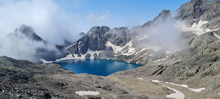
Ambling for an hour across the meadow, we spied the Gumba Nullah to our northeast (right side). Crossing the nullah over a log bridge we walked by the banks of a pair of limpid lakes with walloping cows and chirping insects. A little further to the north, we camped on yet another enchanting meadow. It was primarily a vast pasture dotted with sheep, yaks and cows. To the south a glacier tumbled head over heels, over seracs and steep rocky cliffs. Wide grassy slopes rose to our northeast (right) and clouds poured out from the Gumba Nullah gorge. Small finch, sparrows, ravens and wild geese fed in the lake. To the east and west, steep rock faces climbed into the azure. Our colourful tents unfolded like beach umbrellas amidst the green. We had barely gained any altitude through the day and we camped at around 3980 m. Though the ground seemed parched with brown grass a tiny stream close by provided enough fresh water for all of us. This was peculiar of the Himalaya. Even in the driest and seemingly arid places I have often found streams and fresh water puddles beneath stones and within rocks.
Sun greeted us the next morning. True to the naval traditions, we took off at 8 am (each day at this precise hour, all the units of the Indian Navy follow a custom called ‘Colours’, where the naval ensign is hoisted). An easy trail followed the true left bank of the Miyar Nullah, keeping rather close to the water. The ground was abloom with blue iris, petunias and red flowers of unknown origin. Around three hours later we crossed Takdung Nullah with our trousers rolled up as the bridge had been washed away. Soon we came across Chhudong Nullah where some of my members decided to walk across a slippery plank, though it seemed dangerous to me. While one of the porters wobbled across the plank, the member who followed tumbled and fell into the turbulent water. Though the other two behind him, pulled him out in time but not before he had gulped some amount of water and had lost his shoes. He was thoroughly shaken and stirringly wet. We had to get him into dry clothes immediately as he had begun to shiver. It took us close to an hour to cross the nullah down stream. From there we cut across diagonally towards a rock and boulder strewn slopes. Shortly we walked across a grassy meadow with a huge cairn and reached our campsite that sprawled across a sandy ground with a stream flowing by like a girdle around the meadow. We were camped just ahead of a point marked Dali Got on the map, which was practically the snout of the Miyar Glacier. We were now at 3900 m. A jagged rocky peak jutted out to our south, which had a fine line of rock that I was sure was yet to be attempted.
Next morning we set off early, heading for the jumbled medial moraine of the Miyar Glacier. We came across a series of red arrows, which were actually misleading since the glacier had, since the glacier had altered its structure drastically, hence they led nowhere and after few hundred meters we came to a point where we had to decide for ourselves if we wished to go to left or right. While the porters, led by the sirdar, claiming to have done this route two years before headed for the true right bank I scrambled over a column of tottering boulders and headed for the true left. Finding an easy trail I climbed onto the ridge and strode ahead keeping my feet purposefully on each stone. Far below, the porters were walking through the maze of boulders and moraines, trying to find a path to climb on to the ridge on their side. My team followed me from a considerable distance. It was a narrow glacier and we all knew where we were headed and there was only a remote chance of anyone getting lost or separated at the end of the day. The high ridge kept me above the moraine and I made good ground. I was roughly following the 4100 m contour. Point 5755 loomed like a swooping pterodactyl to my right. By now the porters appeared like colourful dots on the other side as they appeared intermittently through the moraines and rocks. Soon the clouds descended and a drizzle started.
Soon I lost the animal trail and walked purely by the map and my instincts. Occasional cairns cropped up as suddenly as they disappeared. Gradually I left all remnants of green and entered the world of rock and ice. Tip-toeing across slippery rocks lodged into hard ice, I traversed far above the glacier where several glacial lakes reflected the dull sky. It was tricky and time consuming as the rocks kept on sliding over the hard ice. I dislodged several rocks that plummeted out of sight. I had absolutely no foothold and barely any handhold since all the rocks were loosely perched atop the ice. I crossed the junction with the Jangpar Glacier and headed further into the jumbled mass of ice and rock. It was more trapeze than trek as I jumped nimbly from one rock to another, while dodging others that fell from above. Nearly seven hours into the day, I stopped at a clearing for the members to catch up with me. Though they were tough, they found it hard going on such ground. After some time we descended to the main glacier and crossed it width wise to join our porters onto the other side. Only the fastest of the lot had reached while others still struggled behind. We camped for the night on bullet-hard ice at around 4400 m. Unable to dig our pegs into the ice, we used rocks to anchor the tents. As the twilight settled in, I looked back at the Jangpar Glacier and discovered several virgin peaks of varying technical challenges rearing out from the valley. A summit of twin peaks seemed really a hard proposition.
Next morning we headed north keeping to the centre of the Miyar Glacier. The cloud base was low. The lower edges of several hanging glaciers from nameless ridges gaped at us from either sides. We gained altitude steadily. After several hours, we scrambled on to the central moraine to avoid stepping into glacial streams that were now numerous. A magnificent icefall joined the glacier to our right. Several virgin peaks of around 6000 m or above opened up on both sides. Eventually the glacier careened to its right and we sighted Kang La pass right ahead, around 3 km further up. We camped on the ice at around 5100 m near to the ice flank of the peak 6141. While we pitched our tents, the sun shone briefly and the wind picked up fiercely. Our boots sank on the soft snow. The dusk rolled in silently and we retired for the night.
Excitedly we all got ready for the day’s march as it would see us across our first big pass, Kang La. Stark blue sky and a brilliant sun shone from above. Stripping down to our base layers and stuffing ourselves with rice and dal and fried eggs, we marched ahead across the vast expanse of the glacier. A huge crevasse field tumbled to our right, hence we kept to our left and zigzagged over the steep ice wall that led up to the pass. Though we weaved through numerous crevasses, they did not hinder our progress as they were exposed and it was easy to circumvent the deadly traps. Precisely at 10.55 am we topped Kang La pass (5468 m). The panoramic view from the top was fabulous as we looked down into Zanskar. We posed and took pictures along side the prayer flags. Kang La was crossed by trekkers going from Miyar to Padam. We spied a group of hikers ascending from the other side, towards Kang La. The pass was rather windy and we quickly descended over the soft snow. This pass took us right across the Great Himalayan Axis, into the Zanskar range. Far below lay the confluence of two streams, one emanating from the Kang La icefall and the other from the Tidu Glacier. We headed for this as it would be our campsite for the day. From there we would deviate from the normal trail and head off towards Kishtwar across the Poat La pass. Leaving the icefall we again entered moraine and finally reached a sand dune covered campsite sandwiched between the two streams. The path going to our right (NE) headed for Padam. While in the opposite direction almost due west the Tidu Glacier moraine and ice ramps rose into the setting the sun. Located right at the junction of two valleys and streams, the campsite was unusually windy and sandy. That evening along with our food, we must have gulped a good amount of silica too.
Right from our campsite we climbed through the medial moraine of Tidu Glacier and headed straight up as it was pointless to look for a trail since none would be found. As we moved up and down, in and out of moraines and ridges, rocks crashed around us alarmingly. Could be the result of a warm and windy day. I walked steadily but slowly, as it was really hot. The team was well scattered and spread across the glacier. Everyone walked at their own pace. While I continued deeper within the glacier, my eyes remained riveted to the trio of peak 5995 m, 6294 m and 5935 m (from west to east), which girdled the glacier like a choker. Each of these was virgin and could give even the best of the climbers a really hard time. The icefall below peak 6294 was horrifyingly rotten. The glacier turned to the right and far above and ahead, where the flank of peak 5995 met a snow covered rocky ridge, I spotted cairns silhouetted sharply against the blue sky. It was Poat La, our next major objective. We pushed ahead till the moraine and pitched tents at various levels as there wasn’t any level ground in that maze of ice. We made tent bases by placing flat rocks (that were hard to come by) together and filling up the gaps with smaller ones. From here we would veer to the west towards the pass, whereas up towards the cwm of the glacier lay two superb peaks of 5609 and 5763, both virgin.
On 18th August, we started off the moment the sun cleared the ridge and climbed steeply over rock and ice flutings, towards Poat La, which looked deceptively close. I walked at the end of our entourage. Avoiding the crevasse field to our left, we climbed through shingles and lose slab rocks that proved to be tough going. Though the leading porter reached the pass in about an hour and half, I took another hour to reach the top. At 5500 m, Poat La was perched dangerously atop a sharp ridge with sheer drops on either side. The drop to the other side, where we had to descend was dizzyingly steep and extremely broken. The magnificent view drove all other thoughts from my mind. Row upon row of unclimbed peaks decked the southern horizon. The pass ridge itself led to few very difficult peaks. The trail on the other side dropped so suddenly and steeply to the ice cwm that one did not see the trail till one had started descending. It was hard to imagine yaks crossing this pass, as one of the porters declared to no one in particular. Keeping several climbing ropes handy we started going down. Even the otherwise nimble footed and loud mouthed porters, I observed, quietened down and used all fours whenever necessary as we gradually lost height. It was a difficult pass and a tricky descent. One slip and death would surely follow. Several times the ones in the lead had to take shelter from the flying rock missiles that the others dislodged from top. After the steep descent we reached the glacier basin of moraines and huge rocks. Navigating through these colossal obstacles we finally reached the little known Zanskari Kanthang Glacier. Right opposite on the other side, two rock walls reared up like sentinels, which would be a rock climber’s delight.
Around 15 km long and 1 km wide, the Zanskari Kanthang Glacier had numerous rocks and ice problems strewn from one end to the other, several topping the magical 6000 m mark, all unclimbed and never photographed from close quarters. One among them could easily be the mini Trango Tower. If only we had climbing gear, I don’t think I would have gone ahead. One could easily spend a month in this small glacier, and climb more than dozen adrenalin-pumping peaks in true alpine style.
On stepping onto the ZK Glacier, we climbed onto the true right lateral moraine as the Glacier itself was composed of hard ice and countless streams. Rohit had been struggling since we crossed Poat La and I had stayed behind for him. While I watched others disappear from sight towards the next glacier, I looked back and saw a tiny dot still coming down the slopes in a slow staggering manner. I had asked the others to go ahead and find a campsite for the night. It had been a long and hard day and rest was paramount in my mind. By the time Rohit joined me, he was on the very limit of his endurance. Pushing and prodding, I coaxed him one step at a time. I took over his pack, yet he could only move barely a couple of steps at a time. The sun had set by now and darkness descended rapidly. We were deep inside the towering moraine blocks, which was dotted with pools and streams and if any of our steps dislodged a huge boulder, it would come crushing down on us. None of the others ahead were in sight. I blew my whistle several times but no reply came.
The situation was fast becoming critical. We had no tents and sleeping bags. No food, no gas or burners. No sign of any drinkable water. Soon the darkness deepened into an impregnable wall of solid black, which seemed to imprison us from all sides. Rohit refused to move even a step ahead. He dropped to the ground and pleaded me to go ahead and look for help. I had no idea where the others were. Just then, I spied few faint light blobs, ahead, flickering like night flies. It was impossible to judge the distance. Rohit’s headlamp had broken so I handed him mine, and depositing him atop a big solidly placed rock at a point which I hope I would remember in the dark, I stepped ahead completely sightless into the black wall. Purely by feel and using all my mountain instincts, I stepped and hopped from one rock to another as I climbed higher out of the moraine and to the slope so that I might have a better chance of spotting some one and vice versa. I blew my whistle periodically.
As I climbed higher and further away from Rohit, slowly his headlamp too disappeared in that murky gloom. I was walking on extremely slippery and treacherous ground, completely blind with no idea of where I was or was heading for. Though the map in my mind knew the general area and the glacier orientations well. Though I had no doubts that we won’t get lost and nothing will happen, I knew that if I slipped and fell into the gaping crevasses far below, I would crush my bones like matchsticks and disappear forever. No one knew where I was and finding a body in that vast amphitheatre was next to impossible. The moonless night kept me entrapped like claws of a marauding bird of prey. The night was unbearably cold and I was worried about Rohit. Though I had wrapped him with all the layers we had, I was worried about the fact that he was immobile, starving and severely dehydrated. After what seemed an interminable period of time, I suddenly saw a pair of lights rather close by, seemingly coming in my direction. I screamed and blew the whistle with all might. The answering whistle sounded like the sweet lullaby of Eden. Soon I united with Padam (our head porter) and his assistant. I led them back to Rohit, who could not move and it was impossible to carry him to the next camp that was still two km ahead. The porters had gone ahead, following a gaddi track and had camped on a narrow grassy patch. Padam informed that another group of porters and members had descended into the Dharlang Glacier and had separated from them. Luckily Padam had carried sleeping bag and water and food. We left Rohit on the rock and moved ahead.
I spent a restless night. We were deep within one of the least visited or explored and magnificent valleys in the entire Himalaya and I did not know the exact whereabouts of nearly half of my team. One officer was benighted nearly 2 km back, and here I was with eight porters and two cooks, counting stars for want of any other options. There was nothing more that could be done that night. The morning came with fresh breath of life and hope. I looked out of my tent and simply forgot for a moment where we were or what had been or still was our plight.
If I had ever seen any prettier sight in the Himalaya then I did not recall it at that moment. We were perched precariously on a tiny grassy ledge at about 4800 m on the true right bank of Dharlang Glacier, just at the junction with ZK Glacier and another icefall. To my south, peaks 6072, 5698 and 5615 (east to west and all unclimbed) spread out like a Japanese fan, coming down to the Glacier in outrageously oversized falls of ice and rock. It was an unusually narrow gorge, filled with glacier ice, rocks and frozen pools with towering rock and ice walls rearing into the azure that was now painted gold and orange and all aglow with a brilliance that simply took my breath away. Numerous sheep droppings confirmed that it was a shepherd trail that we had found. We were on the right track. Padam and few others went to look for the team that had descended into the Dharlang Glacier, while I went back to fetch Rohit, who was much better despite his night out. This was his first ever outing in the mountains and I knew he must be finding it really hard but he was his cheerful self and looked none the worse. In fact he seemed rested and recuperated and ready to go. The other team joined us shortly before noon. We regrouped and after a heavy brunch strode ahead. Today we would do a short stretch and then rest. Our line of porters and members spread across the trail and I brought up the rear with the ever-smiling Tien Singh. He had been in this valley as a child with his uncle, and he kept pointing to me the peaks and the sights he remembered from then.
We lost altitude gradually, almost following the contours. Succeeding ridges opened up more streams, adjoining glaciers, ice falls. We waded through the Bodh Nullah and descended to a grassy meadow. Sheep and yaks dotted the green field and few horses loitered around. There was no sign of any human though. The mountain slopes on either side bustled with violet, yellow and red flowers as they danced in the breeze. Butterflies fluttered, honeybees buzzed from one bloom to another. Birds twittered, hopping over ground looking for food. It was a real paradise after so many days of rock and ice. We camped right next to a stream that weaved through and around our tents. So I could just stretch my hand out of the tent and find the freshest water in the world. High above us, we saw a sheep and few men. Soon few gaddis came down to greet us. We chatted and from them I gathered as much information I could about our route ahead and about our next objective, the dreaded ‘Sersank Pass’. What I heard was not encouraging. The glacier leading to the pass had totally broken down, with steep icefalls and huge crevasses opening up. It was impossible to cross this pass without climbing equipment and certainly not by such a large group as ours – the shepherds opined. The weather was again closing in with dark clouds plastering the sky. For Sersank La we would need perfect weather.
On 20th August we rested. The sky was partly overcast. While others washed and dried their clothes and generally lazed around, I climbed up the neighbouring ridge to get a wider view of the Shiv Shanker Glacier and the Sersank La. Sitting alone at around 4800 m, as I looked across the Dharlang Glacier and stared at the huge tumbling jumble of ice and rock, I knew that Sersank La was out of question for a team like ours. We were too large and too ill equipped. Over the years the glacier has broken and fallen head over heels, gorging out rock bands, making it a near vertical maze of around 800 – 900 m of extremely treacherous ground, through which only a strong set of four to five experienced mountaineers equipped with safety and ice climbing gear could go through. Properly equipped it was an easy proposal, but not without the right gear. Moreover, our porters would not be able to do it at all. From where I stood, and even if climbed higher, the actual pass was hidden and I had no means of knowing what lay up there. At 5239 m with a steep rocky descent on the other side, I decided to skip Sersank La and that offered two options of exiting from this narrow valley. Either we walked due west, along the Dharlang Nullah and came out at Machel and from there by road to Kishtwar and Jammu or cross the high and rarely used pass of Dharlangwala Jot and enter the remote Huram valley of Kishtwar. From there loop back across the Shipu ridge into the Pangi valley of Himachal into Killar. As I jogged back to the camp, I took yet another look at the majestic peak of Shiv Shankar, which dwarfed the rest of the ridge. At 6002 m it was a giant in that area. As far as I knew it was still a virgin. This region was so rarely visited by climbers or hikers and so little has ever been written about these mountains that nothing could be claimed or said with conviction.
While coming down, I again met the four gaddis and asked them about Dharlangwala Jot. I matched their description with the map and it tallied. They confirmed that an occasional shepherd did cross this 5086 m high pass from the Dharlang Valley into Hurum Valley. They assured me that the trail was well marked and the pass had little ice. That would be our track. That night rain poured incessantly.
Tien Singh and I started early, ahead of the others as we had to find the base of Dharlangwala Jot. We kept to the true right bank of Dharlang Glacier, high above the nullah, following gaddi trail. After a km we started going down towards the nullah. We walked fast, leaving Sersank La behind. Large wide pastures with grazing horses and sheep opened up. We crossed over a side stream, using a rickety wooden plank as bridge and hugging on to steep rock cliff for support. At several places side streams came down and widened before joining the main stream that we were following. We hopped, skipped and jumped from stone to stone and whatever else to avoid wetting our feet. Then we came across a group of nomads comprising of very severe looking women, few unruly and dirty kids and one very old man. They spoke in pure Kashmiri and we barely understood a word. The inevitable dog, bared its teeth at us and strained hard at its leash. We took pictures and walked ahead. A km and half ahead we came across one solitary muddy hut in the middle of nowhere. Tended by one woman and her son and daughter, it had three of the fiercest dogs I had ever seen in the Himalaya. She offered us buttermilk that we gulped down. Handed over sweets and Cadbury dairy milk to the kids and we sped ahead. The son wanted to come along with us to the pass.
Around another cliff, we saw a rickety bridge filling the chasm over the rushing waters of Dharlang Nulla. We had to go across and it would lead us to the base of the pass. Two small gaddi huts seemed a welcome sight. We literally ran across the bridge that seemed to be on the verge of a colossal collapse, askew as it was. A lone gaddi came down from the mountain to greet us in a mix of the local dialect and Hindi. He was Gaffur and he was tending his 60 odd sheep. He confirmed that the pass could be climbed in about 5 hrs from where we were. It was a perfect camping ground. Red flowers sprouted around through the lush green grass. The sheep had fattened to no end. We quickly pitched our tents and waited for the others to catch up. Soon everyone had assembled and we camped for the night.
Dusk came sweeping the valley with magic wand, painting the glaciers red. A gendarme outcrop atop a rocky peak on the opposite side of the nullah looked straight out of Harry Potter world. Who knows, there might indeed be a witch or a fairy godmother who resided in that rocky castle. We were at around 3740 m and it had been an easy day. I chatted with Guffur till late, inside his hut, and learned a lot about gaddi life and their way of life. A gentle rain pattered through the night.
The next morning, Gaffur’s uncle, Khursheed Alam came to meet me. He was an affable man and well travelled who had been to Delhi once and remembered fondly the Red Fort and Jama Masjid. He offered to show us the begging of the trail to the pass. We had around 1400 m of vertical ascent to the pass over very slippery ground. A heavy fog had descended and visibility was almost zero. It was wet, cold and rather windy. We started around half past eight. After crossing a stream we climbed straight up into a boulder-strewn field that was steep and very slippery. People disappeared, appeared and disappeared in and out of sight like a conjurer’s trick into the fog and around and over the rocks. It was tough going and no one spoke. Our heavy breathings filled in the air. We followed sheep droppings as there was virtually no trail as such. Far below and opposite, Dharlang nullah fell away rapidly as we gained height. We could see the entire length and curve of the Dharlang nullah as sun played hide and seek through the dark clouds. After around three hours we reached a gorge filled with a misty waterfall. Leaving the waterfall to our left, we discovered a trail through a grass covered rock gully that led straight up into the sky. It was so steep at places that we had to use all fours. After emerging from the narrow gully, we met another massive boulder strewn slope that took us above and across a hanging glacier towards the pass. After we topped the glacier, we saw the pass on the horizon. The Cairns were sharply outlined against the darkening sky. The pass was the lowermost point on the ridge connecting two high and very steep pointed rocky spires. The approach to the pass was totally iced up under a tiny glacier with huge crevasses. We tip toed gingerly and climbed to the pass with utmost care as lose rocks and slab ice bombarded and crashed from the top without rest. One of the rocks hit a porter on his hand and left a deep gash. He was immediately given first aid. We resorted to step cutting at few places. The porters used rocks to crush the ice and also scattered mud at places where the ice was too hard. I slipped at a place and went down several meters, braking hard with my bare hands. I escaped with superficial injuries and a bruised palm. By now it was snowing heavily and the shifting sandy ground that led up to the pass was wet and sinking. We kept sliding and slipping and dodging stones all the time. My bruised hand was totally caked with mud, rock pieces and the open wounds pained. At round 4 pm we reached the pass. It had been a long and enjoyable and challenging climb. The top was extremely wind as the adjoining valley unleashed its stock into the one from where we emerged. The breeze cut through our bones and the temperature plummeted alarmingly with every passing minute. The snow continued unabated. I put on the gore tex jacket. Few of our porters huddled under rocky outcrops to keep out of the wind. I observed others coming up from the glacier. Within the next half hour everyone had been accounted for except one porter and three members. From the height we had an extremely long and wide view of the entire glacier below but there was no sign of them. Keeping Tien Singh with me, I send the others down to the other side to set up camp and start the kitchen. Sun was setting and it was getting colder and colder. Once again things were turning dangerous. Even after 2 hrs of vigil from the top, which had by then frozen our limbs, we saw no sign of the four. I decided to go down again to the glacier and start a proper search for the missing four. Tien Singh and I discovered a safer route from the top and reached the glacier within twenty minutes. Walking rapidly, with headlamps on, we quickly reached the lower glacier and the moraine, walking back upon the trail. Around a glacier table, we found the ‘four’ slumped on the ground. We shepherded them and literally pulled them up to the pass and drove them down the other side. We reached the tents around 8 pm. The sky had cleared and the half-moon sprinkled its mirth down upon us unabashedly. The stars soon joined the symphony of the night and a grand orchestra lulled us to sleep.
The morning of 23rd August found us relaxing across the slab rock strewn campsite, drying up our clothes and sleeping bags under the warm sun. We started off just short of 10 am. We descended rapidly towards the Huram Glacier and the nullah. Soon we were across the rocky area. To our left Huram nullah cascaded down like a timid stream. The glacier was more of an icefall. Typical of Kishtwar, the opposite ridges were all decked with gravity defying hanging glaciers and massive waterfalls. Soon we reached plush meadows and green pastures. To our left (south) was a deep gorge with overhanging glaciers and 90 degree rock faces, while where we walked it was decked in green grass punctuated by myriads of yellow, red and violet flowers. Countless streams and brooks criss-crossed our trail. This was Kashmiri gaddi haven and the green was dotted with sheep, lambs, horses and cows. The vista was so exotically beautiful that I could have stopped at every step and stay there forever. Further ahead, where it rapidly disappeared into the horizon the nullah dropped away, turning towards the villages of Tun and Bhatwas. I stopped often to gaze awestruck at nature’s handiwork. If this did not prove God’s existence then nothing will… I mused. Around half past one we were just 4 km short of Tun and if we wanted we could have reached the same day. But I wanted to soak the landscape as long as possible and finding a rather vantage point we camped for the day. The expedition mood was now buoyant and boisterous. Everyone sang songs and enjoyed the views. It had been an easy and thoroughly enjoyable day. What a contrast it was since yesterday!
We woke up to a cloudy morning. The cook, sensing that we were nearing the conclusion of our expedition, prepared a sumptuous meal. We followed the true right bank of the nullah and lost altitude through the day. The valley was widening up every minute. Huram Nullah had been for most past a quiet stream, but after a lacustrine dam, it started tumbling ferociously. Blocks of truant ice paved bridges at places. Nain Bahadur Shahi, my porter companion regaled me with tales of his village in Nepal and his survey work in Himachal. We finally descended into the immense grazing ground of Sanyot Adhwari, where the Billing Nullah united with the Huram. Nain was an expert medicinal plants and herbs collector. He showed me few Shillajit outcrops, far out of reach, stuck to rock faces. A gaddi boy loafing nearby informed that there used to be a pass up the Billing and Larsa nullah that led to Dharlang and Machel, but was not used anymore. We crossed Billing over a bridge and immediately waded through cultivated fields of potato, green peas, maize and barely. The fields were in full bloom. We were nearing the village of Tun, our first village since leaving Urgos over a fortnight ago. Soon we crossed a long ‘mane’ wall and then came Tun.
The typical Tibetan houses with flat roofs and black framed doors with running nosed kids and red cheeked women welcomed us heartily. Sonam, our only Ladakhi member, finding his brethren, beamed ear to ear. He must have got the whiff of chhang (an intoxicating brew). Only seven families and around 30 folks populated Tun. They were clearly Tibetan and Ladakhi in origin. None of them knew how they reached here across the high passes or when or why. We rested on the open roof of the village chief and then walked ahead further down through the villages of Alya, Khizrauni and Muthal, Chag and finally camped on the Chaund camping ground right next to the gurgling Sansari Nullah. A group of young Kashmiri women visited our campsite in the evening and showing none of the restraint or coyness that they are normally associated with, they visited each of the tents and even entered our kitchen tent looking for male company.
On the 25th morning we crossed Bhatwas and then the bridge across the Sansari nullah. The trail went through thick wood of pine, deodars and chinars littered with generous amount of bear droppings. Soon the trail started climbing rather steeply towards the Shopu Pass. We had descended to almost 2800 m and now we had to climb over 600 m straight up to the pass that will lead us across the Shopu ridge and back into Himachal, Pangi valley. Though really steep, the climb did not seem tiring. We crossed a shepherd and his tribe of 100 sheep. Nain and I were much ahead of the rest of the group. The trail eventually entered a deep narrow gorge and climbed at almost 90 deg zigzagging sharply across stones and mud and uprooted tree trunks. Climbing this through rain would be a nightmare. At around half past ten we topped the pass. Far below us the Sansari Nullah glistened under the sun. Soon we reached the village of Dharwas and from there managed a lift on a tipper to Killar, the main village in the valley. The rest of the journey to Manali would be in roadways buses and I thought that all dangers were over. A day later when the bus (if it could be called one) flew and literally growled around blind turns and over the largest potholes in the Himalaya, throwing us from one side to another, with babies screaming their heads off in sheer fright… cruising like a maniac on the worst road I had ever seen, I realized that our troubles were far from over. One wrong move by the driver and all the 60 passengers will reach a watery grave into the foaming waters of Chandra Bhaga River to our right. Respite came in the form of a massive landslide stretching nearly a km. The bus shuddered and jeered to a halt just inches from the chasm. We poured out of the bus literally climbing on top of the one in front as if our lives depended on it. We had to walk the entire length of the landslide and get into another bus on the other side. The bus did not go far as the evening swept in abruptly and we were off loaded at village of Shom, where we stayed in the deserted forest rest house. The next day caught the same bus of yesterday night back to Udaipur and then on to Keylong and Manali.
It was the evening of 27th August when we reached back to Manali after a wonderful journey that stretched across 18 days, 156 km on foot, crossing four high and very dangerous passes over four long and crevasse riddled glaciers stitching together four remote valleys of the Himalaya. We had succeeded except for Sersank La that we could not cross. We hadn’t done so badly after all, keeping in mind that we did it totally through the maps and had managed to photograph, explore and record some of the last blank spots in Himalaya. My only regret being that we lost one porter in the process.
Just before we reached Shopu pass, a stone suddenly zipped out of the woods and fatally injured the young Min Bahadur Thapa, who died on the spot. A second earlier, and that stone would have taken me down. The young boy had taken leave from his apple picking job at Manali and came along with us, hoping to make some extra money for his old parents back home. There was absolutely no reason why he should die that day and at that spot. We were out of all dangers and were on easy grounds. It was the last day of our hike. But he died. I knew that he wouldn’t be the last. These lofty and gorgeous mountains would claim other lives too. As long as men went out into the wild, there would be some who will not return. I wish to dedicate this expedition and this article to the memories of the young man who did not return. May his soul rest in peace.


A totally mind boggling tale of your expedition, though my mind is totally jumbled up with all the numerous names of passes, some heard before some totally new, thoroughly enjoyed reading this, S :-) also gave me more insight to your love of the mountains and the unseen.
ReplyDeleteEnding was sad and wish Min Bahadur Thapa would be alive, but death is inevitable and such is life, so like u ended, may his soul rest in peace.