Talang Pass – following the goat trail from Tang to Holi

Chamba side view from Talang Pass, Mani Mahesh Kailash in the center
At 4667m Talang is touted as the highest pass that local shepherds use to cross the Dhauladhar Mountain Range from Kangra to Chamba and back during their annual migration with their herds. This pass had been on my radar for several years and this year since the pandemic put a hold to my international trips, I finally crossed it. In this post I won’t talk much about the pass history itself rather give a factual account of how we crossed it. Suffice to say that till now Talang Pass has very little mention or details online. And I wish to fill up this void through this article. I will also give our exact itinerary that we followed. You would be able to follow the details in this post in case you wish to do this pass unguided by yourself. A word of caution before I begin, that this indeed is a very difficult pass and unless you are an expert hiker with very steady head for heights, in good physical condition and posses a high degree of navigational skills, just don’t attempt it. It is objectively dangerous as well and there’s a good chance of injuries and accidents. The fact that the hardy shepherds cross this pass regularly mean nothing since they are super human.

Trail ascending towards Khargoshni Mata after Chamunda Temple
Day 1 – we had hired a minivan to drop us from Tang till the
end of the road to
 |
| Kanda Got ahead 2800m |
The ridge descends around 150m as it curves to right and then to left. From in between you should be able to see your first night’s camping ground at Kanda Got. We spied several blue tarps that shepherds use as shelters. The trail finally descends to the Got. It’s a wide area on top of the ridge with a majestic waterfall in the background that comes down from Talang Pass. Keep walking till you find a water source to your left. It is basically a water pipe that shepherds had drawn from the waterfall. Beyond the water point there’s a flattish patch where we camped for the night. We were at 2800m and it had taken us nearly 9 hrs. There were couple of shepherds around us. We cooked dinner and then lit up some dry woods for camp fire.

Waterfall where you go down and then go up steeply
Summary – 0730hrs Tang to end of Himani Chamunda Road
(1400m) by minivan. Started hiking at 0800. Reached temple at around 1200hrs
(2900m). Reached
Day 2 – today we anticipated a long day as we intended to cross the pass. We started at around 6.30am. The trail goes up straight towards the distant waterfall for around 30 min and then dips down to the right. We reached another shepherd after an hour, perched at the edge of the slope overlooking the waterfall. We had to descend all the way to the bottom of the waterfall and then climb up steeply across it. One of the shepherds was going back to Talang and he agreed to walk with us, which I think was godsend. The trail descending to the bottom of the waterfall was rather precarious with several exposed rock sections where we had to climb down very carefully using our hands. On a wet day this would be truly dangerous. We lost 400m at the bottom of the waterfall where we drank to our hearts fill and also filled up our bottles as there’s no water for the next three hours or so.
 |
| Waterfall crossing point |
From here the trail climbs steeply along a very narrow and slippery trail carved out of the mountain side with several tricky traverses with long exposed drops to our right. It is not for someone with vertigo. We had to use hands at several places. About 200m higher up the slope broadens and eases up. From here it was more like hiking up. The trail is very well marked. We got bit delayed as two shepherds were coming down with several hundred sheep between them. After they crossed us, we continued to climb. We reached Triundi from where the trail is littered with huge boulders and is constantly steep and demanding. By now the sun was up and the heat was rather unpleasant. Around mid way the trail turned left where it got lost amidst big rocks and boulders. I was on the lead and following the shepherd who nimble footedly hopped from one rock to another. The other four were slightly behind. The trail finally reached a gigantic boulder right on the edge and then turned sharply right and went down to meet the stream that leads to the massive waterfall that we had crossed in the morning. Here we started climbing pretty much alongside the stream through a wide gully. It was breathtakingly beautiful.
 |
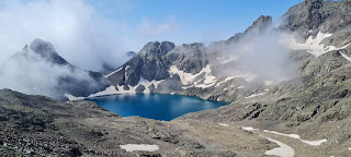
| Shepherd shelter where we camped and cooked at the lake camping below the pass |
The climb was hard and steep. Far above I could see the snow covered top of the pass. The trail here is not so clear but you can simply follow the one that is going up. There’s goat dropping everywhere. Stay at the middle of the gully and towards the top veer to your left and you will find the correct trail. We emerged at the top to the camping ground next to the twin lakes. It was nearly 2.30pm and we decided to camp there for the night. The shepherd left us and soon disappeared up above into the clouds. We were now at 4200m. Two of us slept inside one of the shepherd rock shelters while I pitched my tent and the other two took the 4 men tent. At night we could see the sparkling lights of Yol and Kangra.

Lake camping below the pass
Summary – started at 0630hrs from Kanda Got at 2800m. Reached the twin lakes beneath the pass at around 1430hrs at 4200m. Big camping place with plenty of water.
Day 3 – we started again at 0630hrs. Skirting the lake over ice patch, we followed the goat droppings and trail up. You got to keep more or less at the centre of the face that goes up. You can easily avoid all the snow patches on the slope by skirting around them. The trails are confusing on this climb so best is to follow the goat droppings, which we did. As we climbed higher, the twin lakes beneath aglow in the morning sun looked amazing.
 |
| The lake |
 |
| Looking back while climbing the last stretch to the pass |
 |
| Final climb to the pass |
Finally
we emerged at the top and found the Talang Temple to our left slightly below
the pass top. There’s a considerable snow field on top. We took 1.5 hrs to the
top. We did some puja and other holy rituals at the temple. From there we
reached the snow plateau and the vista to our North, spearheaded by the conical
dome of
 |
| Nearly at the top. The temple is to the left |
 |
| Talang Temple at the top |
 |
| Going down to the glacier on the Chamba side |
Now we had to find the path to get down on to the glacier on the other side. You should traverse to your right till you exit the snow and then you will find a narrow trail with goat droppings. Follow it further to the right. It then turns left and plunges straight down a horribly screed and slippery muddy slope for about 20m. It was tricky getting down this slope. We had to be very careful of the slippery slab rocks and scree, lest we started a rock slide. After about 20m from the top we exited to the right to a projecting boulder and then down climbed through more boulders to the glacier. The glacier on the Chamba side is massive, widely spread, with significant crevasses. There’s no trail over the snow at all but one must follow the goat dropping. We followed the dropping to the left. We took another 30min to get out of the snow and found ourselves among boulders. Here too there’s no marked trail so we followed the goat dropping. Our aim was to keep traversing diagonally to our left and keep losing altitude. We found a central ridge with streams on either side, going down and we followed this ridge. This entire area is full of spectacular waterfalls of various size and volume. Once we got to the grass we found a well marked trail. There’s plenty of streams around so no need to carry too much water. At around 4000m we found a snow bridge across a nullah and crossed it to the left side. From here there’s plenty of goat dropping and trail to descend further. Soon the trails vanished into thick forested wild plants and we simply broke through the vegetation, keeping as far left as we practically could. Now we had all the streams and waterfalls to our right. Further down the gorge got deeper and narrower. At a point there’s a massive few storey high boulder where we picked up the trail again. From here the trail climbs a bit through thick forests towards the left following the natural curvature of the mountain. It crosses a difficult and dangerous rock patch with barely any room to wriggle across over a chasm. After this it plunges down further till we reached a stream and from there across to a shepherd camping ground with prearranged kitchen stone and wooden poles. This was Aah at 2800m. Today we had been on the move for over 10 hours. We pitched our tents and cooked a remarkable dinner. From here onwards we were in thick bear country so you should be careful not to stray away alone into the forest. There’s plenty of dry woods for camp fire.

Aah Camping, there's stream nearby
Summary – started 0630hrs from the twin lake (
Day 4 – today being a shorter day we took it easy and
started around 0730hrs. The trail is well used and marked by the shepherds and
goat droppings. It goes up gently through the forest and then turns left,
crossing two big streams and group of small waterfalls the trail then turns
right and abruptly gets steep and slippery. Finally bringing us beneath the

climbing Jutta Dhar 
Looking back at Talang pass from Jutta Dhar
Note: Talang is among the hardest passes that I have done in
the Dhauladhars and should not be taken lightly. The ideal season to cross this
pass from Kangra to Chamba would be either in


this one's beautiful for sure but its also surely out from my bucket lists of pass crossing in the Dhauladhar's ;)
ReplyDeleteAmazing journey... Do you have a GPX file of this trail.
ReplyDelete