Singhar Pass (Jot) 4350m – journey to the killer pass

Singhar Pass, temple and view of Chamba side
After a brief respite once again my friend Ravinder from Tangroti and I headed up to yet another Dhauladhar pass connecting Kangra with Chamba. This time our objective was the dreaded Singhar Pass, which has also been called the killer pass. To my knowledge, this is the only Dhauladhar Pass that even the Gaddis (shepherds) are bit wary of crossing. Hence trekkers crossing this pass is extremely rare. I know of only one instance before us that of two friends of mine, Rijul and Tarun, both seasoned hikers. A brief mention about the pass altitude. Figures vary about its height but according to my altimeter and referring to Army Survey maps I would place the height between 4330 to 4350m hence I would settle for the higher figure of 4350m. The pass ridge is rather long so it depends at which point you cross it. My estimate of 4350m coincides with the lowest point on the ridge, where the temple is located and to which the trail leads. Now I will briefly describe our itinerary with as much details as necessary for you to undertake this hike unguided.


Nitya Cafe, it has camping tents
Day 1 – ideally we should start the hike from the
village of Thalla, which you can reach by public bus from Palampur. But if you
have your own transport or hire a taxi then it is better to do what we did. My friend
Gulshan drove us through Lohna Road along the true left bank of the Neugal
Stream right till the Om Hydropower house that also has a rest house near
Darklu Village. From there we hiked for fifteen minutes after crossing the
stream to

Day 2 – we started sharp at 0630hrs after a light breakfast and packed lunch. The trail rises sharply from behind the café straight up to the ridge top, and then turns northwest (right) following the ridge contour, rising steadily. To our right we could see the magnificent cascade of Vindhyavasini Temple waterfall. This cascade tumbles straight down for over 400m and it had half rainbows midway. We met couple of shepherds, then walked through a massive split rock. The dry grass was overgrown so one has to step carefully as there’s a long drop to our right. After an hour or so we reached a massive tree, beyond which there’s a trail to our left that comes from Thalla.

Soon thereafter we crossed a barbed wire and took the trail dipping slightly to our right. From here begins the forest trail. We were happy to find some shades as by now we both were rather warm from the climb. Around 20 minutes more and we reached at the corner of the ridge where stood a solitary temple. The forest ended here and now we could see the entire span of Khala (shepherd grazing ground with couple of mud huts and a water point).

At around 2200m it was a superb
place to camp and gaze at the towering Dhauladhar up ahead. From Khala the
trail heads north, going down slightly till it crosses the Sethunal stream.
This stream is so refreshing that we had to drink from the gurgling water.
After this the trail heads east through thick forest and begins to climb. We
crossed a massive rock cave shelter than a big exposed rock with tiny cracks to
place our toes and fingers. Thereafter the dry grass covered trail does several
steep switch backs and climbs steeply to


From
 |
| Thatri Gaddi shelters |

 |
| Gaddis at Nahar 2600m |
 |
| Thatri |
We were now at around 2600m. Hearing of our intended journey, they tried to dissuade us from undertaking the journey. In fact they admitted that even they avoided this route since there was another, easier, but longer trail to Singhar. Which of course we ruled out. As Ravinder is a genetic gaddi, I think the shepherds were more worried about me, as my week long white stubble, slight frame and huge backpack brood no confidence in their mind. They repeatedly told Ravinder in their dialect not to take this path. Realizing that we were determined nevertheless, they told him the dangers that lay ahead. As we walked further, I simply blew those cautionary words into the breeze. But I would realize the next day that the shepherds were rather accurate. From Nahar the trail is rather tricky. You simply stay in the middle or right hand side (true left bank) of the stream, plenty of boulders to hop and keep your feet dry. Around half a km up, you will see a landslide slope on your right with bits of pack ice reaching right till the water. Here you must step out of the stream to your right and zig zag through the land slide up and to your left and you will find the trail that climbs rather steeply through grass and trees till it turns to left and traverses all the way to a point where it crosses a side stream. We crossed the stream and found a nice camping ground on the other side. The water was barely 20m from us. We pitched camp at 2850m and decided to go for the pass next day.

Our camp next to this waterfall cascade

 |
| Chef Ravinder in action |
 |
| Traverse to the camp at 2850m |
Summary –
Day 3 – today being our big day, we woke up at


Narrow ledges, high boulders, strategically placed blocks of stones resembling steps, highly exposed and near vertical slopes. We had to be very careful. Higher we went the scenery kept on getting more and more exciting and the dangers more and more intense. Then we came to the rock traverse that the shepherds had told us about. It’s basically a 15 to 20m traverse with very little foot or hand hold with a long gaping drop beneath. In wet conditions I don’t think I would dare to cross this section unroped. After this the trail continues to climb steeply as before. In most places we had to use four point climbing techniques. The gradient and the seriousness of the climb did not ease till we topped 3800m and found subsequent ridges on the other side with the pass rising steeply right in front of us. At this point we made a tactical error since there were multiple trails. Instead of staying right at the top of the ridge to our left, we went down and crossed far below soon reaching dead ends or meandering trails. So we had to climb back up and finally rediscovered the trail at around 4000m.
 |
| The dangerous rock traverse |


 |
| Final trail to the pass |
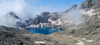
To avoid our mistake this is what you must do: at around 3800m when the trail eases out in gradient, just stick to the ridge top on to your left even though you would see several flat trails beneath you to your right. Do not go down. Keep going up towards the left till you reach a big rock shelter of shepherds with cairns. Here and there you would find rock steps as trails. At around 4000m you would traverse slightly towards your right and you would cross two streams (which we found to be dry at this season), from here you will find the proper trail to the pass. There are further two steep gullys to ascend and two tricky traverses till you start seeing the pass cairns. Stick to the trail and soon you will reach the tiny temple at the pass. We got there at around 1040hrs. By then we had a mini hurricane blowing. It was freezing and we could barely speak. Even though the sun shone brightly into the blue sky, our digits froze in seconds. The tiny temple houses few tridents, bells and a modern looking Shiva, Parvati and Ganesha statue. But the ancient wood carved statues impressed me more. Typical to his belief, Ravinder brought out his prayer paraphernalia and commenced his holy offerings to Lord Shiva. He prayed and I clicked pictures of the Chamba side, where we could see an amazing array of peaks of Lahaul, Bada Bangal, Manali Region, etc. The trail goes down gently on the other side across a boulder ice field next to a lake. We went down a bit to have a look and then returned to the pass temple. True to the shepherd description we found a much gentler trail coming from our east. Lest we freeze, without further ado, we took to heels and started descending. Soon we left the safety of the flattish gradient and started tumbling through the boulders and dry grass. This became truly dangerous. At many points we had no other option but to sit and slide upon the grass as our footwear didn’t find any purchase on the smooth dry grass and shining rocks. Despite our combined experience we had to focus our entire mind and body into each step. Over the next hour I don’t think we exchanged even a single word. Down climbing the exposed rock that the shepherd had cautioned us about was quite dangerous. Thereafter all the big boulders that we had to climb down through made my knees ache. By now we both were dehydrated and a mild headache started. Finally we reached the water point at 3100m and had our fill. Another half an hour and we reached our camp at 1500hrs. Looking back up we both thanked Shiva and our stars for no mishap. As we shook hands, Ravinder observed in his gaddi style wisdom, that if he was to ever cross this pass again then he would go down to Chamba side rather than come back to Kangra side. We cooked a massive helping of rice and dal for dinner.

Summary: started at 0600hrs from camping at 2850m. Reached water point at 3100hrs at around 0700hrs. Reached Singhar Pass 4350m at 1040hrs. Started descending at around 1130hrs and back at camp at 1500hrs.
Day 4 – today we were relaxed and started at 0800hrs.
We were back at Nahar in 40 minutes. The shepherds welcomed us with big smiles.
They offered us piping hot goat milk that we drank gratefully. We rested here
for over an hour. Three of them were heading to Palampur so they decided to
walk back with us. They had to carry two baby goats in their backpacks as they
were bit weak. Our return journey was full of gaddi stories and joyful
laughter. At a point beyond Khala we found fresh bear pug marks. We finally
descended to
Note: I feel our decision to bypass Thalla village altogether was a good one as it shortens the hiking duration for the first day.


Nitya Cafe is my kind of a cafe ;) The pics are stunning! loved the landscape!
ReplyDeleteah, Ravinder sir from ABVIMAS. Nice seeing a familiar face.
ReplyDeleteAlso, thank you for the blog and pictures. Would you happen to have a GPS log of this trek (and others in the area), by the way?
your blog is the way i found about travels
ReplyDelete