As our last pre-winter Dhauladhar trek of 2021, Ravinder and
I chose the rarely visited high pass of Kundli. At 4550m it is mostly used by
the shepherds returning from Chamba to Kangra during autumn. Seldom by trekkers.
It is a difficult pass with unclear trail marking above Shindi Maata
temple (last camping ground of shepherds) on the Kangra side and hardly any
trail at all on the Chamba side till you are well clear of the cliffs and reach
the tree line. Please do this trek only if you are physically fit and with a
guide who knows the trail well. During our 4 days trek in the final week of
October, water was difficult to find. I recommend you finish this trek as any
other Dhauladhar trek, positively before mid October. Our team comprised of
four: Ravinder, Arun
Khanna, Akshu (a young local boy)
and self. We packed food for five days since the trek is of 4 days.
Day 1 – Tangroti Khas
– Kharota (1600m) by taxi. Kharota – Thatarna – Hoddi (2800m) trek. Total hiking
time approx 4 and half hours.
We packed our bags, lunch and took a taxi till Kharota,
where the road ends. The trail begins as flight of stone steps, which goes up
steeply into the forest, following the ridge above Kharota. It is easy to
follow. An hour later we found a water point. From there soon we reached the
wide grassy meadow of Thatarna. Few minutes of rest later, we continued
following the true ridge top and after several ups and downs, arrived at Hoddi
camping ground. We met two shepherds with their flock. We pitched our tents on
a flat patch. Here the water point is around 100m down towards west direction
from the camping. We had fire at night, watched a magnificent sunset and
settled in.
Day 2 –
Hoddi (2800m) to Khabrotu (3300m). Total hiking approx 2 hrs 10 min.
The two shepherds told us to pretty much follow the slope
right above our camp towards the North, straight up. We gained altitude
gradually. Though our earlier plan for today was to get till Shindi Maata
/ Alyas goth at around 3600m, the shepherds advised us to go till Khabrotu
camping where there was some water. In around 2 hrs we found the water point
and then another 50m diagonal traverse brought us to the wide grazing ground of
Khabrotu at 3300m. The trail above Hoddi isn’t very clear, so just follow the
slope straight up from Hoddi camping. While we spread out our tents and kitchen
items, Arun and I went up to do a bit of exploration. We followed the
continuous ridge above Khabrotu and found the well marked trail. We gained the upper
ridge then reached the alyas goth cave and Shindi Maata
temple. We continued further till up to 3800m, placing cairns and stone markers
and returned to Khabrotu. The night turned out to be rather windy.

Day 3 –
Khabrotu (3300m) – Alyas Shindi Maata (3600m) – Kundli Pass (4550m) – Mandrala
(3100m). Total hiking time, from Khabrotu to Kundli Pass approx 5 hrs. From
Kundli pass till Mandrala approx 5 hrs. Total hiking time around 10 hrs.
In the moonlit twilight, at around 5am, we followed the
trail ahead and up from Khabrotu camping. It is easy to find. The trail follows
the ridge line till the upper ridge then turns right continuing to follow the
ridge top till we reached Shindi
Maata temple. From there we
traversed to the left and then reached the bottom of the wide gully (dry nullah) (during monsoon it must be full
of water). We climbed through the nullah,
which twisted to the left and we followed the faint goat droppings and
trails through massive boulders. At around 4000m we topped the ridge and found
the permanent icy slopes ahead and to the right. We turned left and got on to
the ice and continued climbing. From here the trail is again visible through
the rocks, mud, and the droppings on hard ice. The serpentine path kept
swerving to the left. We emerged from the hard ice field to find big boulders
strewn all around. Towards the far end the trail again turns right and up along
a broad dihedral, where rock slabs are placed for steps. The final fifty meters
to the pass follows a narrow flight of loosely kept rock slabs. At around 10am
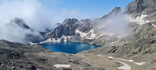
we were at the pass. There’s a small shrine with several tridents etc. The
northern slope was totally covered in thick ice and compact powder snow.

After offering some prayers at the pass we descended through
ankle deep snow. With sparkling blue sky, visibility was good and we could see
all the high mountains of Pir Panjal and Mani
Mahesh Kailash
range. After the snow field came the tottering boulders covered in thin ice
making our progress slow and slippery. Once across the boulders we faced sheer
cliffs till Galod
Dhar camping, where we took a
short break. There was excellent mobile signal for Airtel and Jio at Galod Dhar.
From there, following some streams we continued further down towards the green
meadows far below. Here there’s no trail till we hit the forests. We had to
stay on the true left bank of the main stream, which had considerable glacier
atop. The trail through the forests was often misleading still the narrow
valley kept us going in the right direction. Once we entered the tree line
there were many waterfalls and streams and there wasn’t any shortage of water
at all. Finally we reached Mandrala camping and stayed inside the cave shelter.
I pitched my tiny single tent below the cave. The nearest water point was the
stream, around 15 min away, 80
m below.
Day 4 –
Mandrala (3100m) – Kuwarsi Village (2250m) – Lamu (1900m). Approx trekking time
till Kuwarsi 3 hrs. Another 30 min to the bridge. From the bridge by taxi till
Lamu.
Being a short day, we started at around 8 after some tea and
snacks. We got Airtel signal at Mandrala. I called up our friend, Chamail at
Kuwarsi to keep some breakfast ready. The trail, though very well marked and
visible, is tricky at places and you should be careful. In an hour we reached Bangini Maata
temple and offered prayers. Finally we reached the junction with the Indrahar
pass trail and then descended further to the Naag temple and to Chamail Singh’s
house at around 11am. We gorged on piping hot paratha, masala tea and cauliflower
veggie. Around noon we headed further down till the road head bridge, from
where a taxi dropped us at Lamu at Ravinder’s uncle’s place. Hot shower, veggie
pulao and lots of chatter. The night got rainy and it snowed heavily among the
mountains. We were sure glad that we hadn’t been caught in the rain and snow. Our
timing was perfect.

Conclusion: though this is a difficult hike, the trek from
Kangra side to Chamba side is easier to follow. In the monsoon and summer
months I think it would be more difficult due to poor visibility and high
grassy slopes.


Comments
Post a Comment