Nikora Pass (Jot) 4760m – the forgotten trail to Bada Bangal

For long I have been fascinated with the region of Bada
Bangal, nestled within, literally surrounded by high Pir Panjal Range of
mountains from all sides. The only access to this remote and unique village
that doesn’t require crossing a high snow bound pass is from Holi side, along
the dangerous Ravi River gorge from Nayagran. This trail is arduous and
dangerous. Of all the other passes that leads to Bada Bangal, Nikora is the one
that I found most intriguing since this pass doesn’t find any mention in the
official list of passes of Himachal Govt. notifications and there’s absolutely
no mention of this pass anywhere online, no images, no reviews (now it does)
except few vague mention in an obscure survey of India map and few odd places.
Over the last 18 years of my exploring these mountains I hadn’t met anyone,
including local shepherds who had crossed this pass from either side. At 4760m
this is certainly a high pass and was perfect for my explorer’s instincts. My
friend

Kugti Village
Day 1 – we had a hearty breakfast along with sweetened chai (typical of the region), and headed off into the main village square where we found Lovely, the only resident of Kugti who has done mountaineering courses, and his instructor had been Ravinder, so it was a happy reunion of the student and teacher. Lovely readily agreed to come with us for the day to carry some of our stuff as we were heavily loaded. Soon the three of us crossed Kugti and turned right to cross the Dudhil Nullah (milky stream) across a rickety wooden bridge with the frothing river rushing far below. A perfect spot for bungee and zip lining. Then we hiked up for around 500m through dense forests to the flat pasture ground of Dalotu. I was simply struck speechless with the view. I had never seen such a vantage point anywhere in the Himachal, from where you could look down into four distinct valleys, each crowned with hanging glaciers and unclimbed peaks galore. From left to right the first valley led to the popular Kugti Pass with the Keylong Temple (Kartik Temple) in the foreground, the next valley led along a beautiful river with wide open pastures heading towards another remote and unused pass (which I intend exploring next year), the valley to its right was where we were headed. Dalotu is a perfect camping ground. It has a water point as well.
 |
| Dalotu Camping |
From Dalotu
we descended sharply for about 300m to the stream that we crossed over a wooden
bridge. On the other side we started climbing up through a very well marked
trail. This trail is the one that pilgrims follow to undertake the pilgrimage
to
 |
| L to R - Ravinder, a gaddi, Lovely |
 |
| Gaddi dera |
 |
| Bridge crossing after coming down from Dalotu |
Summary - started at 0730hrs from Kugti (2600m), reached Dalotu (3100m) at 0900hrs. Reached camping ground at 3800m at around 1415hrs.

Camping at 3800m

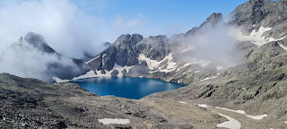
Day 2 – We woke early and after a light breakfast started at 0600hrs. We crossed the stream across the snow bridge then followed the true left bank of the stream steadily gaining height gradually. It was freezing as we were still in the shadows. As we crossed 4000m, towering peaks surrounded us. We had to cross the stream several times very carefully as there were considerable number of verglas on the boulders that we had to step upon. We hit the glacier moraine at around 4300m. Right ahead we could see the notch on the ridge where I supposed Nikora was. The glacier was gentle enough for us to walk without crampons or ice axe. There were odd crevasses but nothing to worry about. To our right I could see a massive glacier tongue, which we decided to explore later. We gained altitude steadily till we reached at 4700m where a massive bergschrund obstructed our passage further. From here looking straight up we could see some ancient cairns at the Pass. We crossed the bergschrund from its right edge and looked up at the final 60m to the top of the Nikora Pass. Since this pass hadn’t been used for decades, the entire rock face had deteriorated to mere shambles, full of horrible scree and broken slab rocks. There was a constant trickle of pebbles the size of ping pong balls coming down through the gully that was our obvious route to the top. We neither carried helmets, or pitons and it seemed far too dangerous to go up as I was certain we would set off rock slides and it would be too dangerous to come down later. So I decided against going up the last 60m. At least I knew for sure why no one crossed this pass anymore. We took pictures and did some puja at the bottom and got down. Now we veered to our left towards the other glacier.
 |
| Glacier leading to the pass looking back |

In two hours we reached the end of the glacier, rather the beginning. It ended at around 4900m abruptly at the edge of massive cliffs that plunged heedless nearly 800m straight down on the other side. It was a vantage point as we could see the Dhauladhar Range sprawling in all its glory right from Jalsu Pass all the way to Kundli and Toral Pass including Talang that we had crossed a week ago. Far down we could also see the Ravi Gorge trail to Bada Bangal from Nayagran. After a while we descended and returned to our camping. We had to cross the stream at a place taking off our shoes as the water levels had risen and all our earlier boulder hopping places were submerged. We got back to our camp at 1600pm. It had been a ten hour long day but totally worth it. Ravinder proved his culinary skills as he produced excellent lentil and rice for dinner.


Summary – started at 0600hrs from camping (3800m), reached the bottom of Nikora Pass (4700m) at around 1000hrs. Reached the col at 4900m at around 1300hrs. Returned to camp at around 1600hrs.

Mani Mahesh Kailash peak
Day 3 – we started back at 0800hrs retracing our earlier path. We met several herb collectors on their way up. They find herbs mostly above 4000m. We stopped at a shepherd’s around lunch time and they offered us lamb chop curry with rice that Ravinder enjoyed immensely. Being a vegetarian I stuck to snacks. We returned to Kugti at around 1400hrs. Immediately we caught a jeep and returned to Bharmour.


Note – having spoken to many shepherds we met during this trip and also before and after I realized that Nikora Pass has been unused for decades. No one really remembers when it was last crossed. The climb up or down from Bada Bangal side is also very treacherous and steep hence now the shepherds mostly use Thamsar, Murala or Kalihani Pass to enter or exit from Bada Bangal. In terms for exploration and climbing the Nikora Valley is amazing and offers many days of excursion. The final 60m climb to the pass top is truly dangerous and if you want to do it, please carry ropes, rock pitons, helmets and adequate safety equipment. I would not recommend crossing this pass into Bada Bangal. Our three day and two night itinerary from Kugti was adequate and recommended. There are many places to camp and there’s plenty of water sources in case you wish to stay there longer and do some rock and ice routes as well. Mules and horses can easily go till our camp ground at 3800m and perhaps even higher if they can cross the stream. I would recommend you contact Lovely at Kugti. He is a young charming boy, qualified mountaineer and knows the entire region thoroughly. He is easy to find. His house is a stone’s throw away from the main village square and everyone knows of him.


what lovely flowers and thank heavens for your love for your own self! <3
ReplyDelete