Sunni Bhunku Pass (Jot) 5060m – accursed pass to Lahaul from Kugti

In today’s world of information overload and the omniscient Google, it is rare to discover a pass, trail and a lake that is completely unknown to the outside world at large, save for a legend and folklore amongst the local shepherds and herbs collectors. Such is the way we heard about this pass along with a mysterious lake from the shepherds of Kugti during our trip to the Nikora Pass and Ravinder and I headed to discover this unknown region few days later. This trip was a real exploratory one, purely based upon some stories from the shepherds and we discovered a hitherto unknown and undocumented valley and a pass along with a marvelous lake barely a spitting distance from the popular Kugti Pass. Before retelling our journey, it is important to briefly narrate the legend of Sunni Bhunku, after whom the pass is named by the Shepherds. This name is purely local and has no mention in any survey of India maps or Google anywhere.

Natural rock formations, perhaps a geologist can tell us how this is formed
Sunni Bhunku Folklore – akin to the immortal tale of Romeo
and

Keylang Temple 3100m

Day 1 – we started at 0700hrs from Kugti Village, following
the well marked trail to Keylong Temple. After some tea at the temple we set
off further upon the Kugti Pass trail and reached Duggi Got. At 3200m it is a
wide open shepherd camping ground. Here we crossed a stream across a bridge
then reached the cave shelter point, from this point we diverted from the Kugti
Pass trail and took the path going straight further east following the Dudhil
Nullah stream true right bank. Soon we arrived at

Our Day 1 camping at 3900m 
Chunji Ghori area
Summary – 0730hrs started from Kugti Village (2600m),
reached Keylong temple (3100m) at 0900hrs. Crossed Duggi Got (3200m) at around
1000hrs,

Glacier peaks panorama en route to Murali Lake 
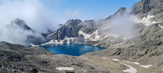
Murali Lake with Kugti Pass behind 
Our kitchen with herb collectors 
Our camp at 4200m
Day 2 – we followed the trail right atop the true right lateral moraine of the glacier to reach the camp ground at around 4200m where we found three more pitched tents of the herb collectors. We pitched our tent, had some tea and decided to hike up to the mysterious lake that our friends had told us about earlier. We had seen this lake marked in Google as a blue spot without any name. The hike started right from our tent, straight up through big boulders. It was a steep trail. Soon we spotted our neighbors bent upon the slopes digging out karu. We crossed them while they shouted encouragements through the morning air. As we got higher the glacier and its ridge line peaks rose like giants to our east, most promising among them a 6000m goliath right at the northern edge where we guessed our elusive Sunni Bhunku Pass resided. More of this peak later. Being light, we gained ground rapidly and soon topped the ridge and just on the other side about 50m below lay the most beautiful lake of emerald and turquoise. We had taken an hour and half to reach 4750m. The lake is roughly heart shaped, about 30m across and 20m wide with sizeable ice sheets plastered along the shore. Right behind it we could clearly see the notch of Kugti Pass and its trail going up from the valley. Further up from the pass we saw a peak that Ravinder had climbed along with a military school team some years back. It’s 5600m high and as we believed that is the only ascent of this peak. They had named it Kartik Peak. We lazed around the lake a bit, ate some snacks enjoying the glorious sun. Since the lake is nameless, Ravinder suggested we name it Murali Lake after a local deity. We got back to our camp and cooked some much needed dinner. In the evening the herb collectors returned and we had a nice chat about local customs and culture post dinner.
Summary – started at around 0800hrs from 3900m, reached camping ground at 4200m around 0930hrs. Hiked up to Murali Lake at 4750m and down in three hours.

Ravinder offering prayers at the pass, we have left the symbolic holy cloth 
The glacier on the Lahaul side from the pass 
Climbing to the pass 
Walking on the lateral moraine 
Peaks on the glacier 
The pass is at the V notch. The peak rising from there is 6000m
Day 3 – the night temperature had dropped drastically and
everything had frozen. We woke up early, I noticed the barometer had dropped by
7mb which seemed alarming indicating bad weather later. We started off at
0630hrs. Following the herb collector’s trail we first walked along the mud-caked
top of the lateral moraine and then descended on the flattish ground next to
it. All we had to do was follow the glacier till its beginning and then head
straight up. The glacier was indeed wide and long, the longest of all in the
region that I had seen so far. It still had massive volume of ice and moraine.
We found several streams further up and considerable amount of flat ground for
camping. If our purpose is to cross the pass then we should camp further up at
around 4500m. Meanwhile, the weather that had been brilliant until now had
started deteriorating rapidly. The wind had picked up and all the peaks were
immersed in thick fog and swirling mist. I could sense imminent snowfall. We
hurried along. Soon we had to step back on to the moraine and then on the
glacier ice, that turned left from the main axis, at the head of which we could
see some sort of stone cairn that indicated the pass location. The ice had
sizeable sastrugi hence posed no problem even without ice axe and crampons. We
just stepped through the maze. Slowly it steepened as we got higher. The ice
ended at around 4900m. The rest of the way was through loose slab rock strewn
constantly sliding scree. By now a moderate blizzard had commenced. We both
were experienced in scree, yet it was tough going, as we slipped and slid from
one rock to another, often disgorging copious amount of dust and loose stones.
We stuck close to each other for safety. Finally we emerged at the top at
around 1000hrs. To our left we saw the ancient cairn. We decided to explore the
other side first. We turned right and looked down upon the glacier below. It
was gentle enough to descend safely towards the Lahaul side. It was quite wide
and large with big exposed crevasses as it curved north. We spied a solitary
ghuggi flower (Saussurea simpsoniana) sprouting from a stone block. This flower
is considered highly sacred and are found in the Himalaya between 4000-5500m
altitudes. It also has medicinal properties. Following the top ridge we looked
down at a frozen lake that is marked as

The sacred Ghuggi flower. We found this solitary flower at the pass
Summary – started at 0630hrs from 4200m and reached the pass top at 1000hrs at 5060m. Returned to our camping by 1430hrs.
Day 4 – we had to dry our tent and wait till the sun hit our camping ground so we left at around 9am, reaching at Kugti Village around 1400hrs. Hitched a ride in a pickup carrying bricks back to Bharmour. Needless to mention that our backpacks were caked in red dust as did we.
Note – Sunni Bhunku Pass at 5060m is slightly higher than
the Kugti Pass, which is the most popular trail from Bharmour to Lahaul, used
by hundreds of shepherds each year. In my opinion Sunni Bhunku is an easier
pass compared to Kugti though it might take a day longer yet I wonder why no
one crosses this pass and no outsider knows about it. Perhaps the curse is true
and the locals fear to enrage the deities. Besides the pass, I am more fascinated by the 6000m peak that rises abruptly
like a raised cobra hood from the pass. I also learned later from a shepherd I
met in Bharmour that from the Lahaul side they call it the Bot Pass. Though I
can’t confirm if that is the case. Even if you don’t go to the pass, I think a hike
up to Murali Lake is rewarding enough. In case you do go to Bharmour and wish
to tackle these treks in the region, including a hike to


I just love those rock formations and am surprised you don't intend to cross the Kugti pass LOL or do you intend to in your next trip???? The flower looks stunning! am glad you left it where it was :)
ReplyDelete